Hiking Project icon

Hiking Project

23.9.1 for Android
3.8 | 100,000+ Installs | Reviews

Adventure Projects

Description of Hiking Project

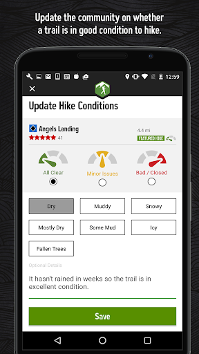
Hiking Project is your comprehensive guide to the best hikes near you, wherever you are.
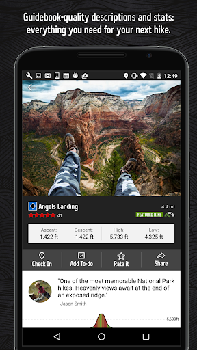
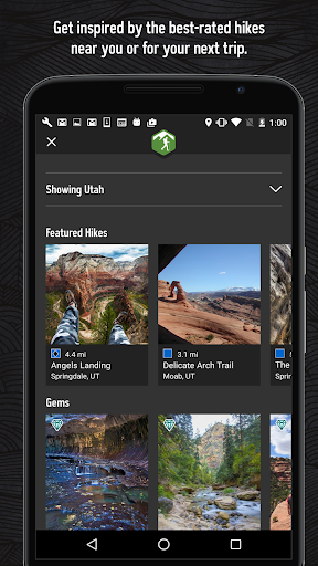
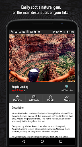
With the thoroughness of a printed map, we offer full GPS route info, elevation profiles, interactive features, photos, and more. Like a guidebook, we suggest the best featured hikes to explore—either near your current location or in an area you search for. Local experts show you the highlights, challenging features, and insights you need to plan a great day on the trails.
• Find over 74,000 miles of trail to hike with your crew.
• New trails are constantly added to our incredibly detailed hiking database.
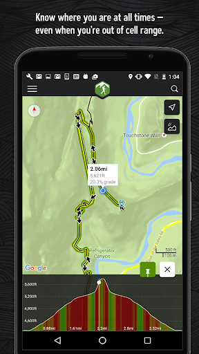
• Your exact location is shown on the trail.
• Downloaded trails work offline for when you’re off the grid. (No cell reception required!)
• Enjoy high-resolution photos and detailed topographical trail maps.
• We’ll sync with your to-do list and check ins on HikingProject.com.
By using GPS, we can show your location on trails and vertical profiles. Continued use of GPS running in the background can dramatically decrease battery life.
Links:
• Privacy Policy: https://www.adventureprojects.net/ap-privacy
• Terms of Service: https://www.adventureprojects.net/ap-terms

What's New with Hiking Project 23.9.1

- Minor updates

Information

  • Category:
    Sports
  • Latest Version:
    23.9.1
  • Updated:
    2023-03-10
  • File size:
    23.3MB
  • Requirements:
    Android 7.0 or later
  • Developer:
    Adventure Projects
  • ID:
    com.hikingproject.android
  • Available on:
  • Hiking Project
    Hiking Project 22.10.0
    10.3MB
    2023-03-10
    APK
    Picture
  • Hiking Project
    Hiking Project 21.14.0
    8.4MB
    2022-03-11
    XAPK
    Picture
  • Hiking Project
    Hiking Project 3.13.1
    9.4MB
    2020-12-08
    APK
    Picture
Reviews
  • avatar
    Wanted to love this app, but when I got to the trail head and launched it, the app needed internet access. Really??? Who backpacks where there's even a phone signal, let alone internet access??? Huge fail!!! Might be a setting or something, but I would expert any such app to default to offline use. Fortunately I also had US Topo Maps loaded on my phone, as well as my trusty Garmin 30x.
    2020-10-20 10:14
  • avatar
    Hard to use. No idea where my "recorded trails" go or if it even records them and vague faqs are the only help I could find. Which means no help. I've really tried to like the app but it's just not worth it for me.
    2020-10-16 11:14
  • avatar
    Great maps and trail info
    2020-09-24 06:46
  • avatar
    Always precise and only needs GPS enabled on your phone. No need for data signal to find your current location
    2020-09-20 04:19
  • avatar
    I hate the new update. I loved this app because I could get accurate information about the inclines at any point of the hike. Now it's super jumpy and not user friendly at all. The range of what the color red represents is way to large. Please bring back the option to pick precise locations on a trail to see the incline or add new colors for steep inclines. Having red represent anything over 15% makes it hard to tell what im really in for, a 50% incline is extremely harder than 15%.
    2020-09-16 05:19
  • avatar
    Awesome app for finding hikes and routes. A note on the new update: please, please get rid of the ting picture to the left of the elevation/mile tracker map. The picture crowds out the most important part of this app! And besides it's too small to see anyway.
    2020-09-11 05:16