Easy to use outdoor navigation app with free access to the best available maps and aerial imagery for the USA.
Choose between 30 map layers (topos, aerials, sea charts, flight charts, ...) to plan the perfect trip and
turn your Andoid Phone/Tablet into an outdoor GPS for offline trips into the backcountry.
Add easily maps from other sources (GeoPDF, GeoTiff, WMS, ...)
Available map layers for USA:
• USGS National Map Topo
• USGS National Map Imagery Topo
• USGS National Map Imagery
• USGS Topo traditional DRGs: Seamless coverage of topo maps of the USA at Scales 1:250.000, 1:100.000, 1:63.000 and 1:24.000/25.000
• Scanned Topo Maps USA dynamic (similar to traditional DRGs)
• FSTopo Forest Maps
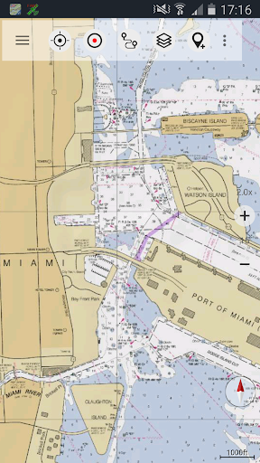
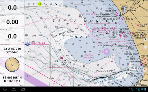
• NOAA Nautical RNC Charts
• Flight Charts
• National Elevation Maps (Hillshade, Slope Map, Aspect Map)
Worldwide map layers:
• OpenStreetMaps (5 different map layouts), also downloadable in space saving vectorformat
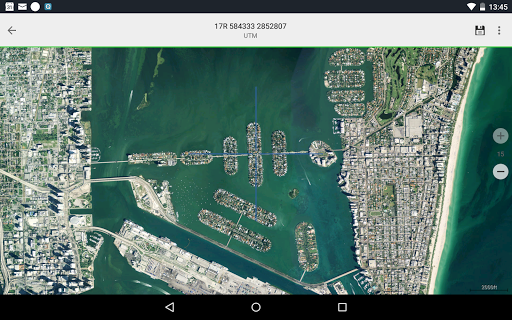
• Google Maps (Satellite images, Road- and Terrain-Map)
• Bing Maps (Satellite images, Road-Map)
• ESRI Maps (Satellite images, Road- and Terrain-Map)
• Earth At Night
Add maps from other sources:
• Import raster maps in GeoPDF, GeoTiff, MBTiles or Ozi (Oziexplorer OZF2 & OZF3)
• Add web mapping services as WMS or WMTS/Tileserver
• Import OpenStreetMaps in Vectorformat, eg complete USA for just some GBs
Available US map overlays:
• Public Land Ownership (Padus2)
• National Hydrographic Dataset
• Motor Vehicle Use Map (USDA)
• 3DEP Contourlines
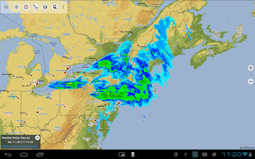
• Ridge Weather Radar NWS
• Wind, Temperature, Pressure
• Wind Vectors
• 6-hr precipitation amount
• 12-hr probability of precipitation
• Surface Air Temperature
• Hazard Warnings
• Tropical Cyclone Track
• Surface Wind Gust
• Total Cloud Cover
Available worldwide overlays:
• Hillshading overlay
• 20m Contourlines
• OpenSeaMap
There is no perfect map. Toggle between the different map layers or use the compare maps feature to find the most interesting route. Especially the old traditional DRGs many small pathes or other features that are missing on modern maps.
Main features for outdoor-navigation:
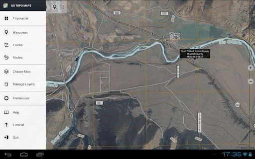
• Download map data for OFFLINE USAGE
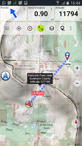
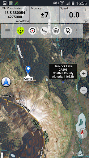
• Measure pathes and aereas
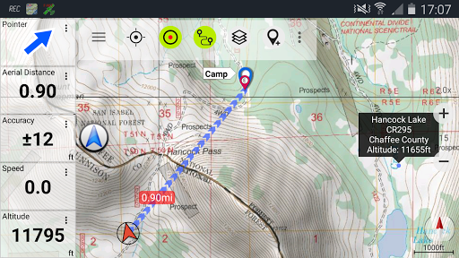
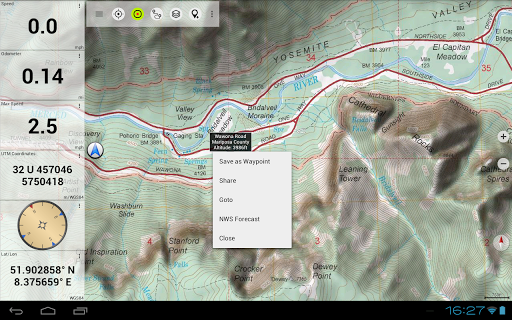
• Create and edit Waypoints
• GoTo-Waypoint-Navigation
• Create and edit Routes
• Route-Navigation (Point-to-Point Navigation)
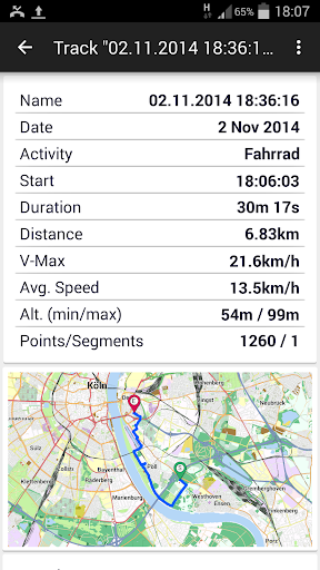
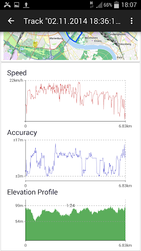
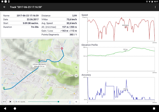
• Track Recording (with speed, elevation and accuracy profile)
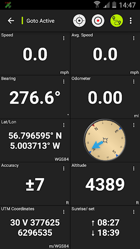
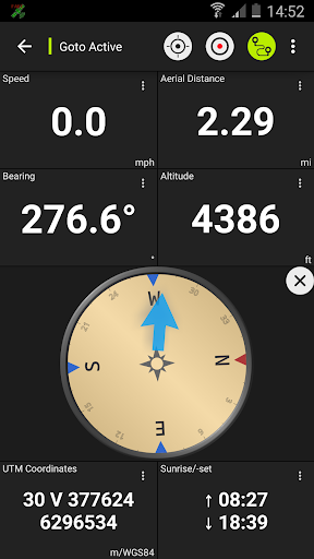
• Tripmaster with fields for odometer, average speed, bearing, elevation, etc.
• GPX/KML/KMZ Import/Export
• Search (placenames, POIs, streets)
• Customizable datafields in Map View and Tripmaster (e.g. Speed, Distance, Compass, ...)
• Share Waypoints, Tracks or Routes (via eMail, Dropbox, Facebook, ..)
• Use coordinates in WGS84, UTM or MGRS/USNG (Military Grid/ US National Grid)
• Get NWS Weather Forecast
• Display Real-Time nowCoast Weather Information and NEXRAD Weather Radar
• Track Replay
• and many more ...
Use this navigation app for outdoor activities like hiking, biking, camping, climbing, riding, skiing, canoeing, hunting, snowmobile tours, offroad 4WD tours or search&rescue (SAR).
Add custom waypoints in longitude/latitude, UTM or MGRS/USNG format with WGS84 datum.
Import/Export/Share GPS-Waypoints/Tracks/Routes in GPX or Google Earth KML/KMZ format.
View Real-time nowCoast weather information like temperature or windvectors and overlay to map.
See animated NEXRAD rain radar to make accurate predictions when raining will start/stop
Please send questions, comments and feature requests to [email protected]
・Fix for routes not displaying in high zoom levels on older devices
・Automatic optional export of a track when the recording is stopped to the public Download directory
・Fixes


9Apps 4.9