
This is an outdoor Tracker using the A-GPS capabilities of your phone. If activated it may record your track even when the phone goes to stand-by.
It is designed in particular for hikers
that
want to record a new path or want to follow an existing track and, more importantly, want to avoid
losing themselves during their return way.
Features:
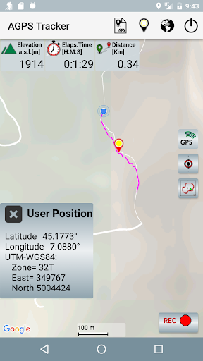
- Elevation is given relative to mean sea level ( note that most android programs don't do this)
- Your Latitude and Longitude coordinates are given in degrees and in UTM-WSG84 (published in paper maps)
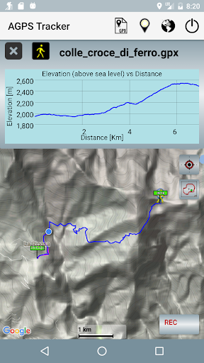
- A track is stored in a GPX file. It
can be recorded, stored or loaded to/from memory and
shared with other people. Its
Elevation vs Distance profile can be shown on the screen.
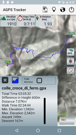
- Statistics of a loaded GPX track will include the net walk time, ascent and descent altitude.
- A "follow path" monitor function can be enabled to provide an alarm in case you are leaving a loaded GPX path.
It is important to understand that this App is good to trace your path but if you want to measure a walked distance the accuracy is not so good. A distance is measured as the sum of distances among the points acquired every 3sec or 5meters, but GPS accuracy is about 10/20meters, if the path is casual( not like a car that follows a road) the final result can’t be very accurate. Errors up to 15% in the measurement of distances are normal.
Errors are determined by several factors. The most important are:
-
quality of received satellite signals, that is poor is the sky is clouded,
-
configuration/relative position of satellites that is continuously changing,
-
reflections of the signals on large surfaces like walls,buildings, etc.
These are the reasons why GPS may get poor position coordinates when GPS signals
are weakened by meteorological conditions and in particular in urban areas,
when satellite signals are received from a multi-path propagation due to
reflections on
buildings.
NOTE:
GPS is used here as a generic term and refers to the capability to receive position data from signals received from satellites. Modern phones can obtain position data from more than one satellite system, i.e. not only the american GPS but also GLONASS, BeiDou and Galileo. A-GPS Tracker will receive data from all the available satellite navigation systems. In addition A-GPS (Assisted GPS) also uses ground sources like cell tower data and WiFi, that may
enhance quality and precision when in poor satellite signal conditions and in particular will help to reduce time to start fixing initial position. GPS will be the source of
the more accurate position: Latitude, Longitude and Altitude.
Note that for hikers Altitude it is of particular importance and can be given only by GPS.
In this release the access to location anytime (i.e. in background)
is not
requested anymore. The app will work in foreground as in releases 3.x


9Apps 4.9


