Are you a fan of outdoor activities and sports? You want to save and plan your hiking locations, routes and to navigate to these hiking locations and routes? This free app is made to enhance your outdoor activities and to solve the most of the problems that hikers face.
GPS hiker tracker application is a powerful navigation tool and designed for outdoors sports and activities like hiking, bushwalking, horse trail riding, geocaching and off-road navigation. This app will help you to save and manage your hiking locations, routes and will help you to navigate to these hiking locations and routes. The application let you record and plan your hiking routes and save them for the review and analysis. For the saved hiking routes you can navigate from your current position to the beginning, to the end and follow the hiking route. You can see all the hiking locations and routes totally on the map as a marker for each location and as two markers connected by one or more lines (the first in the beginning of the route and the last in the end) for each hiking route. Also this app provide you a magnetic compass, you can find an address using coordinates, you can find coordinates and address by clicking on map and you can find the distance in straight line using either coordinates or by clicking on map. Moreover you can get coordinates (longtitude and latitude), speed, altitude, bearing, full address (street address, state, zip, country, etc.) and to see your current location on map using GPS provider in real time.
Features:
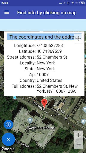
1. Find the address using coordinates. Complete the longtitude and the latitude and see with a marker the point on the map. Click on the marker and see the full address.
2. Find the coordinates by clicking on map. Click somewhere on the map and a marker will be displayed. Click on the marker and see the coordinates and the full address.
3. Magnetic Compass
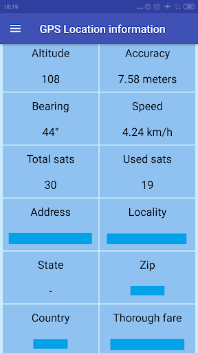
4. You can get the current location information in real-time using GPS provider. More specifically you can get the longtitude, latitude, altitude, accuracy, bearing, speed, provider and the full address every time duration and distance you select by settings.
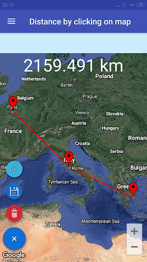
5. Find the distance in straight line between two points using coordinates and between two or more points by clicking on map. You can save and manage the distances.
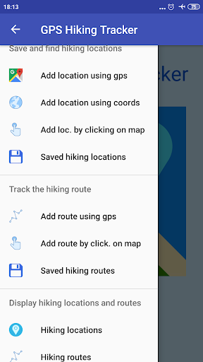
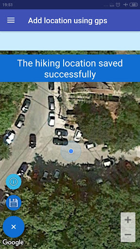
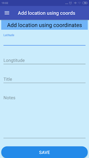
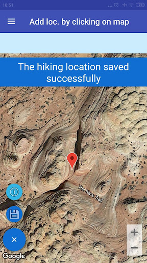
6. You can save and manage your hiking location (in real time using GPS provider or using coordinates or by clicking on map). Moreover you can navigate to a specific hiking location.
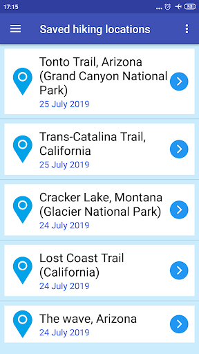
7. You can save and manage your hiking routes. The application let you record and plan your hiking routes (the title, the notes, the beginning longtitude and latitude, the end longtitude and latitude, the start time, the arrival time, the duration, the distance, the max speed, the average speed, the max altitude, the min altitude and the saved - updated date) and save them for the review and analysis. Moreover you can navigate from your current location to the beginning, to the end and to follow the hiking route.
8. You can see all the hiking locations totally on the map as a marker for each location. Click on a marker of a specific location to see the hiking information.
9. You can see all the hiking routes totally on the map as two markers connected by a line (the first in the beginning of the route and the last in the end) for each route. Click on a marker of a specific route to see the hiking information.
10. Settings. There are many settings to help you to adapt the application in your needs.
If select to display or not the current location (when find the coordinates, the distance and add a hiking location by clicking on map) using network location and does not be displayed please clean your cache files, memory etc. from your phone.
I used some icons from icons8.com
v. 1.140:
1. Minor bug fixes.
2. Some User Interface and other improvements.


9Apps 4.9