


Mapit is a professional, stand-alone, cost effective mapping and surveying tool designed to enhance productivity while you are out there in the field.
The app supports common file formats for input and output and is capable to work with number of external GNSS receivers so you can get a centimetre level accuracy when you need to.
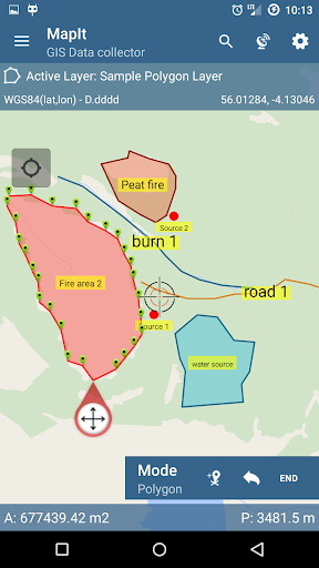
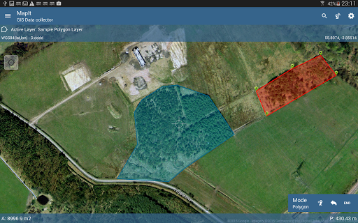
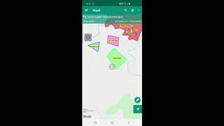
Design your survey forms, organize data on layers, work offline with mbtiles base-maps, access WMS services, use GPS tracking to capture your line and polygon features, record GNSS metadata and much more to discover.
The app is widely used by professionals around the world and can be easily adopted for different applications from agriculture and forestry to road construction, geology, land surveying and solar panel solutions. Personalized settings and flexibility makes this app fit for purpose tool which will enhance your surveying workflow.
App can be also used as a measurement tool to calculate areas or distances.
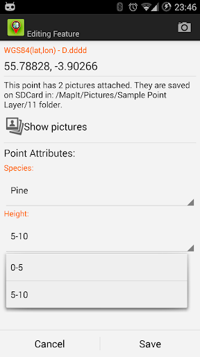
When saving location simply choose required attributes from predefined drop-down list, no need to type the same information over and over again. Import long list of attributes from text files and re-use them in number of projects. If necessary you can add pictures to each location as well.
If you are working in the field, gathering large amount of spatial data this app is designed for you.
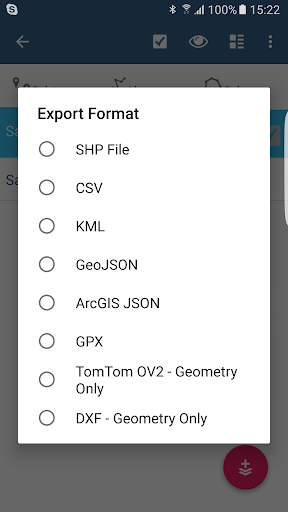
Speed up your workflow and make the data collection more efficient. Take advantage of survey layers and possibility to re-use same set of attributes for multiple surveys. Export your data to common GIS formats like Esri shapefiles, CSV, KML, geojson, DXF, GPX and post process your data using Desktop GIS software like qGIS.
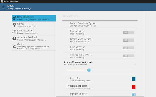
Support for number of predefined coordinate systems and customised EPSG codes if required.
Mobile Data Collection Features:
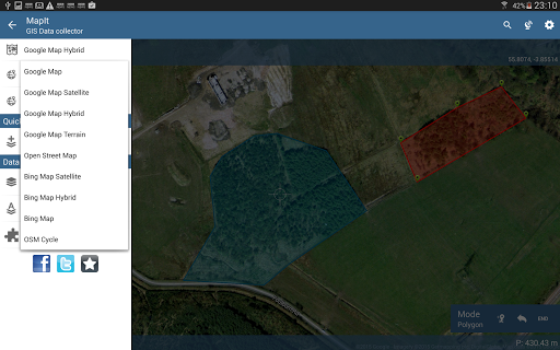
- Base maps: Popular online maps selections and offline mbtiles,
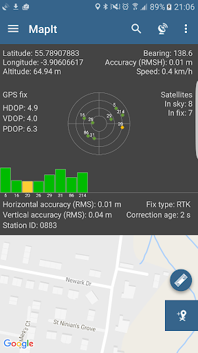
- Support for RTK corrected coordinates when external Bluetooth GPS / GNSS is connected,
- Support for WMS and GIS Server Tiled map services - load topographic and orthophoto maps, geological surveys, cadastral information and number of other services.
- Possibility to create and maintain sets of attributes - these are available as a drop down lists when new feature is being recorded, long lists of values can be imported from text files.
- Clusters for point map markers, efficient way of having large number of points on the map without performance issues,
- Currently 4 methods of collection are supported (GPS / GNSS location, map cursor location, tracking, point projection using angle and distance),
- Possibility to group your data into the survey layers - each survey layer may have a default set of attributes.
- Local SD card or remote export. At the moment shapefiles, KML, CSV, geojson, GPX and DXF export is supported,
- Direct export to Dropbox or FTP location
- Possibility to record multiple points, lines and polygons on one layer,
- When creating new polygon or line features measurement details like area or length are also available.
- GPS / GNSS and satellites status,
- Address, location search,
- Import point, line and polygon features into layer from CSV, KML, shapefile or geojson file,
- Backup management,
- Import/Export attributes from file and much more to discover...
Our users are successfully using Mapit in number of applications including:
- Environmental and woodland surveys,
- Forestry planning and woodland management,
- Agriculture and soil classifications and sampling,
- Road constructions,
- Land surveying,
- Solar panels applications,
- Roofing and fencing,
- Tree surveys,
- GPS and GNSS surveying,
- Site surveying
- Snow removal
Do not hesitate to contact us directly or using the contact form on our website.
FIX: Issue with Accuracy as HRMS reading. When connected to external GNSS this function was not working as expected.
FIX: Accuracy was always exported as HRMS when HRMS was available which was not expected behaviour.
FIX: Other minor bug fixes.


9Apps 4.9


