Maps Measure icon

Maps Measure

1.5.1 for Android
4.4 | 500,000+ Installs | Reviews

j4velin

Description of Maps Measure

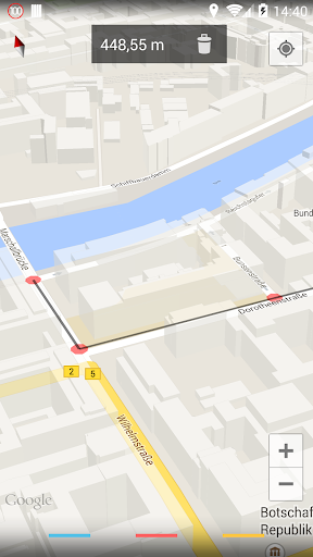
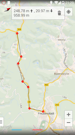
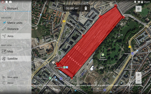
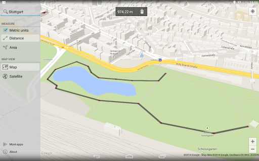
Simple app to measure distances and areas in Google Maps.
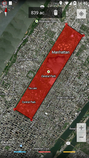
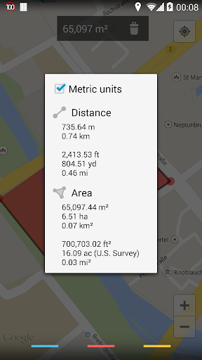
Just click on the map to add different points - Maps Measure will then calculate the distance, area or elevation* between those points.
This app does not calculate a route or something like that - it's not a navigation or route planning app.
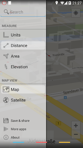
Swipe in from the left side to access more options, long-click on the trash icon to delete all set points.
Features:
• Measure distances, areas & elevations*
• Imperial & metric units
• Map, hybrid-satellite & terrain view
• No ads
• Minimum permissions & open source
• Holo-themed with support for translucent system decor on Android 4.4
*the elevations feature requires an in-app purchase (0.99 EUR, 1.49 USD)
Permissions:
INTERNET & ACCESS_NETWORK_STATE - showing the map and getting altitude data
WRITE_EXTERNAL_STORAGE - caching map data
ACCESS_COARSE_LOCATION & ACCESS_FINE_LOCATION - displaying your current location on the map
BILLING - upgrade to the pro-version through an in-app purchase
The app does not show any ads or collects any of your data.
The app is open source and listed on GitHub: https://github.com/j4velin/MapsMeasure
Icon provided by https://github.com/amirdesaingrafis

What's New with Maps Measure 1.5.1

- fix issue with in-app purchases

Information

  • Category:
    Travel & Local
  • Latest Version:
    1.5.1
  • Updated:
    2023-05-13
  • File size:
    605.8KB
  • Requirements:
    Android 4.4 or later
  • Developer:
    j4velin
  • ID:
    de.j4velin.mapsmeasure
  • Available on:
  • Maps Measure
    Maps Measure 1.4.4
    606.9KB
    2023-05-13
    APK
    Picture
  • Maps Measure
    Maps Measure 1.4.2
    607.9KB
    2018-05-27
    APK
    Picture
  • Maps Measure
    Maps Measure 1.4.1
    444.7KB
    2017-09-14
    APK
    Picture
Reviews
  • avatar
    Does nothing!
    2024-02-09 05:22
  • avatar
    I'm using an older version because reviews say newer one is buggy. What I'm using works great. Near as I can tell the (paid) elevation function is excellent, on one (relatively) flat stretch of road it was actually showing 2' variances over a mile or so (I'd say accurate). The nearby parallel railroad did not, also likely accurate. I realize the base info is Google but having the interface is impressive. Suggest the author make a separate donation app, so one can donate without updating.
    2024-01-10 11:43
  • avatar
    Old version was great, i cant press the rubbish bin now so its completely useless.
    2024-01-08 07:08
  • avatar
    The app is good, but i was wondering if there is a tool or software/app that can help me to extract coordinates of the conner points of the polygon/marked area
    2023-12-18 08:39
  • avatar
    Not working now, location not showing up
    2023-12-04 07:21
  • avatar
    Great app. Easy to use.
    2023-11-02 01:53