
Enjoy the best GPS Topography app on Android, light and effective. Designed to be the definitive replacement for the topographic, pencil and paper notebook; 100% offline. Quickly capture GPS information from your Android device, to collect points, lines or polygons with Google Maps, or; recalculate any polygon, entering data from field measurements, previously or currently carried out, by direct measurement or by radiation
The app calculates UTM coordinates, partial coordinates, errors, corrections (with the Pennsylvania method), offset total coordinates, perimeter and area of the polygon (matrix method). The methodologies used for the calculations are recognized as best civil engineering practices, so the app is considered designed to facilitate the work of surveying professionals and students.
Access the PRO version within the app with a monthly subscription of $ 1 / month, which will give you access to the following functions:
- Generate the DXF file
- Remove all ads from the app
- Remove D3 letterhead in PDF, TXT files
- Remove PRO button from screens and menu
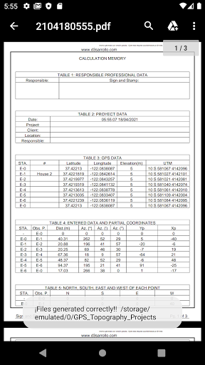
Export your information in a PDF format with a complete report with all the calculation memory, a TXT file to facilitate the import into other programs and a DXF file with the drawing and the topographic notebook / construction chart, designed to facilitate the printing of drawings from your preferred CAD software
This will make your cabinet work more efficient, saving your valuable time. These files are generated by pressing the "Play" button. The three files are generated within a folder named according to the date and time of their creation, stored within the directory "GPS_Topography_Projects" within its internal storage
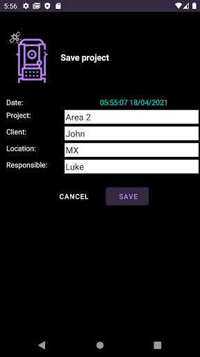
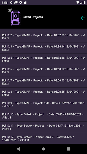
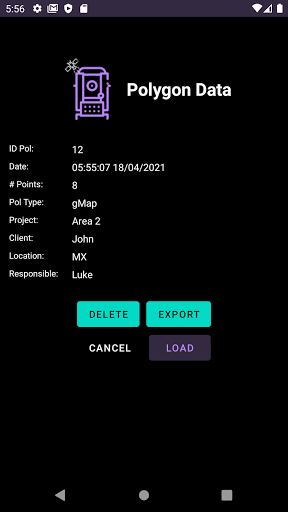
In the app menu you can access the file option, where you can save and load your projects, through a powerful database stored on your device. You also have the option to export your polygon to a comma separated CVS file, which is stored in the "GPS_Topography_Exported" folder, inside your device's internal storage
INSTRUCTIONS FOR USE
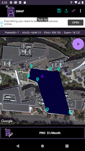
GPS SCREEN (default): use your device to capture coordinates easily, you can capture your current position to measure a polygon by walking on its edges
1. Upon entering, the app will center the screen in your current position
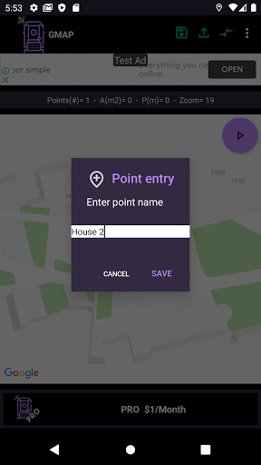
2. Press the screen to capture that point
3. Enter the name of the point in question
4. Repeat the process until you finish entering the points of interest
5. Press the "Play" button
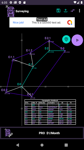
SURVEY SCREEN: generate drawing and digital notebook in real time. Auxiliary polygon points are not considered part of the final polygon and are graphed in light blue, both in the drawing and in the notebook
1. From the GPS screen, enter the app menu and select the option change screen
2. Indicate if the starting point (E-0) is part of the ending polygon or not.
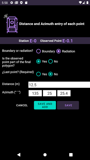
3. To add a station, press the add point button, in the lower left corner
4. Indicate if the line between the station and the observed point is boundary or radiation. If it is a boundary, the code of the observed point will be the next correlative of the station, if it is radiation the code will have the format "XY" where "X" is the station number and "Y" is the number of radiation made from the station "X"
5. Indicate if this line is part of the final polygon or not. Enter the distance (meters) and azimuth (degree, minute, second) between the station and the observed point, taking north as zero and positive magnitude clockwise.
6. Once all your points have been saved, press the “Play” button, the respective calculations are made and the respective files are generated, calculating the data and area of the polygon.
Making topography more efficient!
More information at: www.d3sarrollo.com
- New dark theme
- Now you can subscribe to have all the functions of the app
- Fixed bugs of previous version
- New menu
- Survey polygons, lines and independent points, with your GPS
- Save name for GPS points, to export
- Project can be exported on comma separated CSV file


9Apps 4.9


