


Visorando helps find curated route ideas and turn your smartphone into a recreational GPS, even offline.
Millions of people use the mobile app to explore paths worldwide.
📂 A WIDE CHOICE OF ROUTES
Find routes all over the United-Kingdom, matching your own needs for free - whether it’s a hike in the mountains or a stroll in the countryside, along the coast, into the woods or even in the city-even abroad. From a family walk to a strenuous hike, for a ramble on your doorstep or your next holidays, find what suits you best ! Walk or cycle, choose your own activity depending your location, the level and the duration you wish.
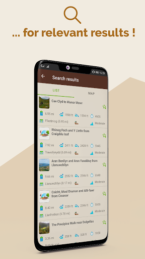
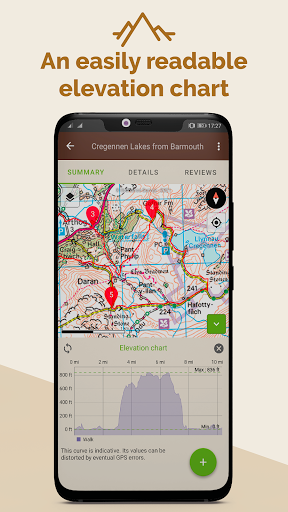
Each route sheet includes an OpenStreetmap map, a GPX, a step-by-step description, length, elevation gain, maximal and minimum altitudes, elevation chart, points of interests, level, weather forecast, and depending on user’s contribution photos and reviews.
Find more than 26 000 curated routes available world-wide (more than 3 500 of which in English).
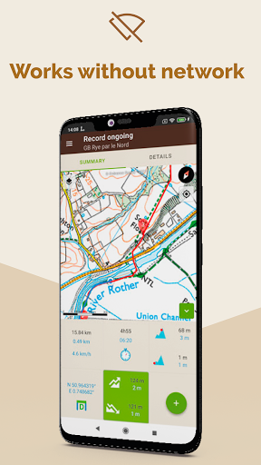
🗺️ LOCATE YOURSELF ON THE MAP AND LET BE GUIDED, EVEN OFFLINE
When you found the right itinerary, download it offline before leaving, then press the button start to follow the route. The GPS app will guide you even off the grid. You will be able to see your live location and your real time progress on the map. If you go off-track, an alert will warn you.
While moving, the actual route is recorded so afterwards you can share it, analyse it, compare it with the one plotted or simply walk it again later.
📱 PLOT AND RECORD YOUR OWN CUSTOMISED ROUTE
Doesn’t any of the route suits you? No worries, you can :
- Plot your own route, thanks to our route planner available for free from your laptop via our website (and from your mobile phone if you subscribed to Visorando Club). When your route is saved on your computer, an automatic synchronisation allows you to find it over all your devices (mobile phone, tablet) where you are connected with your Visorando account.
- Record a live route and follow your progress on the map (distance, duration, elevation gain…). If you lose
yourself, you will be able to find your way back by following the route you just recorded.
- Import a GPX file
⭐ VISORANDO CLUB : Premium subscription to explore even further
We offer Club Visorando during a 3 days trial period when you first register on the app. Then, you can subscribe for £4.99/month or £21.49/year.
Visorando Club give you access to several add-on features such as :
- Access a collection of licensed topographic maps from your mobile phone : OS Explorer, IGN France, Swisstopo Switzerland, Belgium and Spain.
- Share you live position to reassure your loved-ones
- Hour per hour, detailed weather forecast of your route
- Organise and create files to keep your routes in order
- And many more…
Manage your subscription and choose if you wish to have it automatically renewed or not.
⭐ OS EXPLORER MAPS : the reference for any outdoor lover
Users who subscribe to Visorando Club have access to the OS Explorer maps 1:25 000 scale on mobile phone : it allows to precisely visualise, elevation, contours, details related to the terrain. It also offers many information related to tourist and leisure activities, and gather national trails and other public right of ways.
🚶 A QUALITATIVE CONTENT
Visorando is a participative platform and community where anyone is welcome to share his/her own route. To assure the quality of the route published, each submitted one goes through a process composed by several steps, where it is checked and edited by a team of volunteers and agreed with the author, before being published.
📖 MANUAL
A manual to help you use the mobile app is available here : https://www.visorando.com/en-gb/article-user-guide-how-to-use-the-app-visorando.html
➡️ New login and register screens
➡️ Ability to connect via Google / Facebook / Apple
➡️ New optimized interface for navigation on bike walks
➡️ Add arrows to indicate direction of a walk
➡️ Better downloads management
➡️ Fix wrong unit for UK users
➡️ Add Map legend for OS Explorer maps
➡️ Various bug fixes
Enjoy summer walking 🥾🚴⛰️☀️


9Apps 4.9


