

Millions of free Android apps are provide on 9apps. 20,000+ users downloaded Akra - Manikpur Ferry Time Table latest version on 9Apps for free every week! This app has been greatly welcomed in India. This hot app was released on 2019-01-04. I believe you’ll enjoy it after use it.
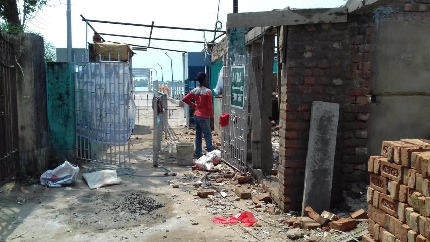
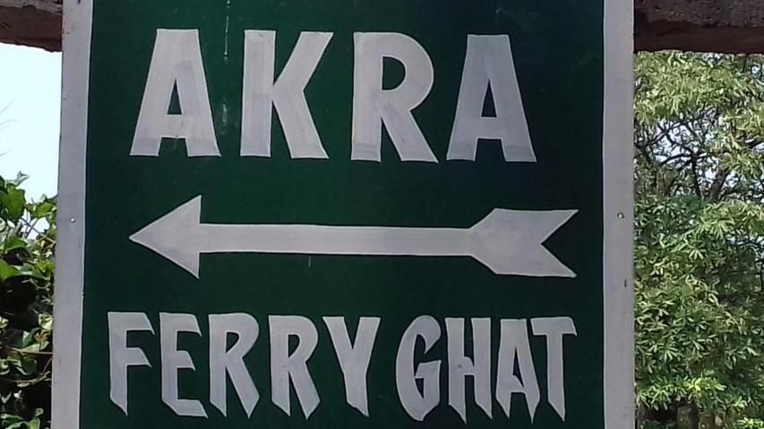
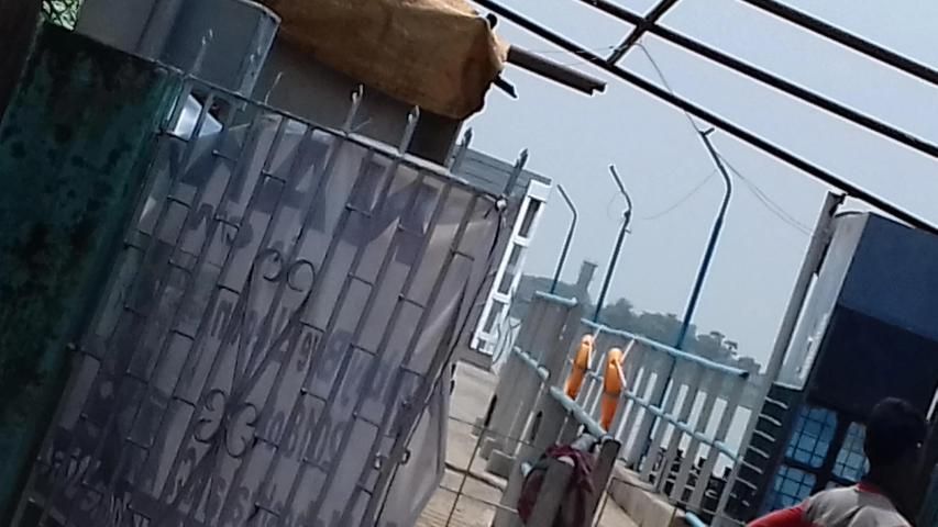
**** This is a Ferry service (Boat) Between To District. People ho cross Ganga River this time table helps them to know time of boats. And it also helps them hat is the last boat/ferry can travel they or not. A total time table the can get from here.
*** what is the tide time ?
when then can`t cross river because of low tide.
**Update its soon Available in Play store.
About something from history of Ferry service from the world --
The profession of the ferryman is embodied in Greek mythology in Charon, the boatman who transported souls across the River Styx to the Underworld.
Speculation that a pair of oxen propelled a ship having a water wheel can be found in 4th century Roman literature "Anonymus De Rebus Bellicis". Though impractical, there is no reason why it could not work and such a ferry, modified by using horses, was used in Lake Champlain in 19th-century America. See "When Horses Walked on Water: Horse-Powered Ferries in Nineteenth-Century America" (Smithsonian Institution Press; Kevin Crisman, co-authored with Arthur Cohn, Executive Director of the Lake Champlain Maritime Museum).
The District Of The 24 Parganas lies between 22° 57' 32" and 21° 55' 20" north latitude, and 88° 20' 51" and 88° 6' 45" east longitude. It contains a total area, as returned by the Surveyor-General in 1871, of 2536 square miles, exclusive of the Sundarbans, but inclusive of the area of Calcutta, which is 7•80 square miles, and of its suburbs, which amount to 23•17 square miles. The population of the District, according to the Census of 1872, which takes the area at 2788 square miles, is 2,210,047 souls, exclusive of the town of Calcutta, but inclusive of its suburbs. Calcutta contains an additional population returned at 447,601 souls. The Census of 1872 cannot, however, be accepted as accurate for the city, and has been condemned. It is the chief town; but the Administrative Headquarters of the District are at Alípur, a southern suburb of Calcutta.
The District as at present constituted is bounded on the north by the Districts of Nadiyá and Jessor; on the east by Jessor, from which it is separated by the Kabadak River, which, after receiving various streams and deltaic branches of the Ganges, takes the following names in its lower course through the Sundarbans, viz. the Arpángási, Bara Pángá, Namgad Samudra, and finally, near the sea, the Málanchá. On the south, the District is bounded by the Bay of Bengal, and on the west by the Húglí River. With the exception of the northern boundary, therefore, the District limits follow the natural ones laid down by watercourses and the sea. In the north-west, the boundary passes for a short distance along the Bágher Khál, the mouth of which lies opposite to Bánsbáriá, a place between the town of Húglí and Tribení Ghát, on the west bank of the Húglí River. After this, the northern boundary passes eastward along old village boundaries, crosses the Jamuná River at Baliáni, and passes on to the bend of the Betná River, whence the boundary extends along the south of Jessor District as far as the Kabadak. Although the southern geographical boundary of the District is the Bay of Bengal, the area in miles given above does not include the Sundarbans, a great part of which is unsurveyed waste land, covered with swamp and forest, and almost uninhabited. I shall give an account of the Sundarbans at the end of this volume, as they are under a special administration. They form the seaboard of the three Districts of the 24 Parganás, Jessor, and Bákarganj.
**** Ini adalah layanan Ferry (Boat) Antara Untuk District. Orang ho menyeberangi Ganga Sungai tabel waktu ini membantu mereka untuk mengetahui waktu kapal. Dan juga membantu mereka hat adalah yang terakhir perahu / feri dapat melakukan perjalanan mereka atau tidak. Sebanyak waktu meja bisa mendapatkan dari sini.
*** apa waktu pasang?
ketika kemudian bisa `t menyeberangi sungai karena air surut.
** Perbarui yang segera tersedia di Play Store.
Tentang sesuatu dari sejarah pelayanan Ferry dari dunia -
Profesi penambang diwujudkan dalam mitologi Yunani di Charon, tukang perahu yang diangkut jiwa di seberang Sungai Styx ke Underworld.
Spekulasi bahwa sepasang lembu mendorong sebuah kapal yang memiliki roda air dapat ditemukan dalam abad ke-4 sastra Roman "Anonymus De Rebus Bellicis". Meskipun tidak praktis, tidak ada alasan mengapa hal itu tidak bisa bekerja dan feri tersebut, yang dimodifikasi dengan menggunakan kuda, digunakan di Danau Champlain di Amerika abad ke-19. Lihat "Ketika Kuda Berjalan di Air: Feri Kuda-Powered di Nineteenth-Century America" (Smithsonian Institution Tekan; Kevin Crisman, co-ditulis dengan Arthur Cohn, Direktur Eksekutif Museum Danau Champlain Maritime).
Kabupaten Of The 24 Parganas terletak di antara 22 ° 57' 32" dan 21 ° 55' 20" Lintang Utara, dan 88 ° 20' 51" dan 88 ° 6' 45" Bujur Timur. Ini berisi total luas, seperti yang dikembalikan oleh Surveyor Jenderal pada tahun 1871, dari 2536 mil persegi, eksklusif dari Sundarbans, tapi termasuk daerah Calcutta, yang adalah 7 • 80 mil persegi, dan sekitarnya, yang jumlahnya 23 • 17 mil persegi. Populasi Kabupaten, menurut Sensus 1872, yang mengambil daerah di 2788 mil persegi, adalah 2.210.047 jiwa, eksklusif dari kota Calcutta, tetapi termasuk pinggiran kota. Calcutta mengandung populasi tambahan kembali di 447.601 jiwa. Sensus 1872 tidak bisa, bagaimanapun, diterima sebagai akurat untuk kota, dan telah dihukum. Ini adalah kota utama; tapi Markas Administrasi Kabupaten berada di Alipur, pinggiran selatan Calcutta.
Kabupaten seperti sekarang merupakan dibatasi di utara oleh Kabupaten Nadiya dan Jessor; di sebelah timur oleh Jessor, dari yang dipisahkan oleh Sungai Kabadak, yang, setelah menerima berbagai aliran dan cabang delta Sungai Gangga, mengambil nama berikut dalam kursus yang lebih rendah melalui Sundarbans, yaitu. yang Arpángási, Bara Panga, Namgad Samudra, dan akhirnya, dekat laut, Málanchá. Di sebelah selatan, Kabupaten dibatasi oleh Teluk Bengal, dan di sebelah barat oleh Sungai Húglí. Dengan pengecualian dari batas utara, oleh karena itu, batas Kabupaten mengikuti yang alami ditetapkan oleh sungai dan laut. Di utara-barat, batas melewati untuk jarak pendek sepanjang Bagher Khal, mulut yang terletak berlawanan dengan Bánsbáriá, tempat antara kota Húglí dan Tribeni Ghat, di tepi barat Sungai Húglí. Setelah ini, batas utara melewati ke arah timur sepanjang batas desa tua, melintasi Sungai Jamuna di Baliáni, dan melewati ke tikungan Sungai Betná, mana batas membentang di sepanjang selatan dari Jessor District sejauh Kabadak. Meskipun batas geografis selatan Kabupaten Teluk Benggala, daerah dalam mil yang diberikan di atas tidak termasuk Sundarbans, sebagian besar yang merupakan limbah tanah dilakukan survei, ditutupi dengan rawa dan hutan, dan hampir tak berpenghuni. Saya akan memberikan penjelasan tentang Sundarbans di akhir buku ini, karena mereka berada di bawah administrasi khusus. Mereka membentuk daerah pesisir dari tiga kabupaten dari 24 Parganas, Jessor, dan Bákarganj.
Ferry Time Table without add
9Apps 4.9