
9Apps services for free Android apps. 10,000+ users downloaded BUSAN METRO SUBWAY MAP HD latest version on 9Apps for free every week! In addition, the latest version of the app has updated a lot of features. This hot app was released on 2013-06-09. Find out more android software you're looking for at 9apps.com
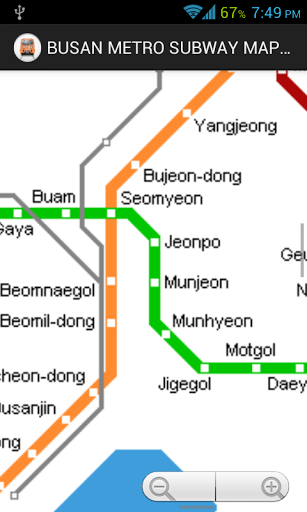
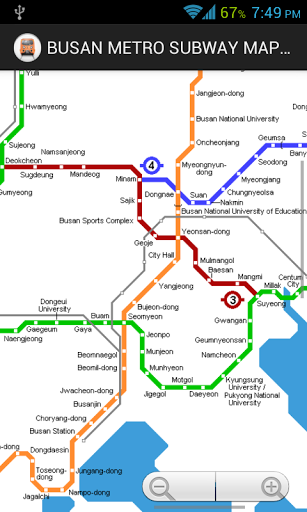
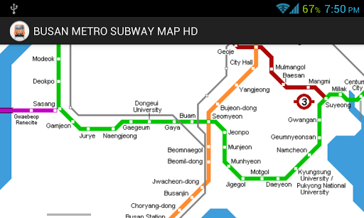
METROBusan (formerly transliterated as Pusan) is South Korea's second largest city (3.6 million inh.; 4.4 million in metropolitan area) and an important sea port on the southern tip of the peninsula.line 1 :: Sinpyeoung - Nopo Dong (32.5 km)Basic plans for the Busan subway were drawn in 1979 and construction started in 1981 on Line 1, a north-south route. It opened in four stages between 1985 and 1994:19 July 1985: Nopo-dong - Beomnaegol (16.2 km)xx May 1987: Beomnaegol - Jungang-dong (5.4 km)xx Feb 1990: Jungang-dong - Seodaesin-dong (4.5 km)xx June 1994: Seodaesin-dong - Sinpyeong (6.4 km) Line 2 :: Yangsan - Jangsan (44.5 km)Construction of Line 2 began in 1991, the western 22 km stretch was put into service in 1999 (21 stations), the central section between Seomyeon and Geumnyeonsan opened on 8 August 2001. One year later it reached its eastern terminus at Jangsan:30 June 1999: Hopo - Seomyeon (21 km)08 Aug 2001: Seomyeon - Geumnyeonsan (7.7 km)16 Jan 2002: Geumnyeonsan - Gwangan (0.9 km)29 Aug 2002: Gwangan - Jangsan (7.7 km)10-Jan-2007: Hopo - Yangsan (7.2 km)01-Oct-2009: Busan national University Yangsan added Line 3 :: Daejeo - Suyeong (18.1 km)Construction of Line 3 started in November 1997 and it was planned to open in 2002 to serve several venues used during the Asian games The largest part of this line was eventually brought into service in November 2005:28 Nov 2005: Daejeo - Suyeong (18.1 km) Line 4 :: Minam - Anpyeong (12.7 km)Initially planned as a branch off line 3, line 4 finally opened as a rubber-tyred light metro in March 2011:30 Mar 2011: Minam - Anpyeong (12.7 km) Busan Gimhae Light Rail Transit :: Sasang - Samgye (24 km)Despite its name, the BGL is a full standard-gauge metro line which connects Busan to the neighbouring city of Gimhae, via Gimhae airport This elevated line is 24 km long, has 21 stations and is operated with 46 driverless cars delivered by Hyundai Rotem.09 Sept 2011: Sasang - Samgye (24 km)


9Apps 4.9