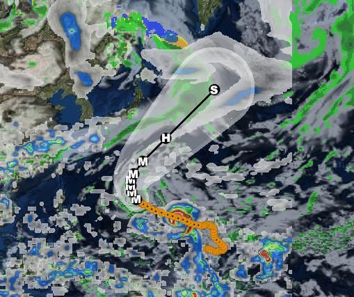
Pacific Hurricane Tracker is an interactive mapping application for tracking hurricanes, tropical storms and tropical depressions in the Atlantic ocean. All data comes from the NHC, NOAA and NWS. Listed below are the featured layers of this application.
-Global Cloud Cover
-Hurricane Tracks
-NHC Chance of Development
-Tropical Storm Tracks
-Tropical Depression Tracks
-Wave Height Data
-3 Hour Precipitation Data
-NOAA Buoy and Ship Observation Data
-GPS Location
-Wave Direction
-Global Surface Winds
Pacific Badai Tracker adalah aplikasi pemetaan interaktif untuk melacak badai, badai tropis dan depresi tropis di Samudera Atlantik. Semua data berasal dari NHC, NOAA dan NWS. Di bawah ini adalah lapisan fitur aplikasi ini.
-Global Hamparan Awan
Lintasan -Hurricane
Kesempatan -NHC Pembangunan
Lintasan Badai -Tropical
-Tropical Trek Depresi
-Wave Data Tinggi
-3 Jam Pengendapan data
-NOAA Buoy dan Kapal Pengamatan data
-GPS Lokasi
Arah -Wave
-Global Permukaan Angin
Squashing bugs.


9Apps 4.9