
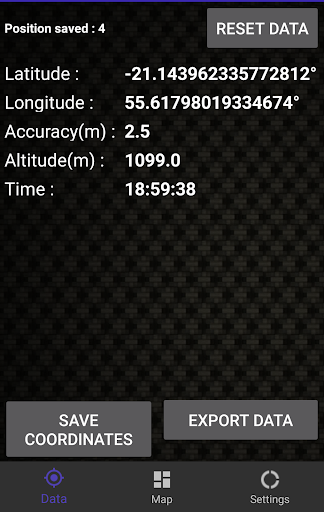
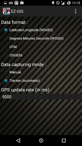
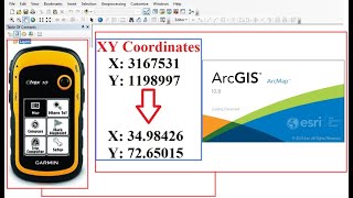
EZ GIS è la soluzione più semplice per, esportazione, e utilizzare le coordinate geografiche, in vari formati. (Latitudine / longitudine, DMS Gradi Minuti Secondi, WSG83, UTM, OSGB36) con una precisione di fino a 1 metro.
Questo strumento GIS è compatibile con QGIS, ArcGIS, GRASS GIS, gvSIG, GIS Collettore, ILWIS, JUMP GIS MapWindow GIS, SAGA GIS, uDig, Capaware, FalconView, Kalypso, TerraView, Whitebox GAT, MapGuide, Mapnik, MapServer, PostGIS , SpatialLite, TerraLib, cesio, GeoTools, GDAL, Orfeo Toolbox, GeoNetwork, pycsw, Camaleonte, MapPoint, GoogleEarth, Google Earth, Autodesk, ENVI, ERDAS IMAGINE, strumenti di Esri, GeoServer & Excel
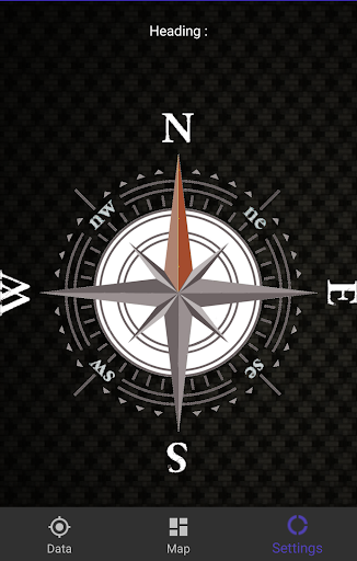
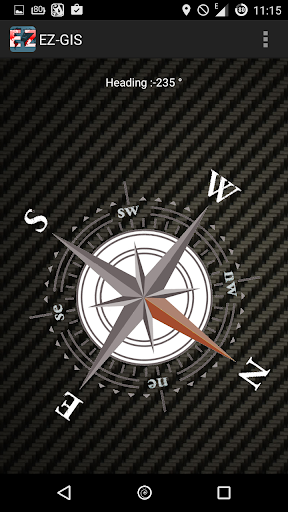
strumento di localizzazione sviluppato appositamente per l'esplorazione archeologica e geografica. lavorare sulla tua Carto diventerà più facile! usare la vostra posizione e punti coordinati, Lat Long e molto altro ancora!
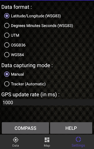
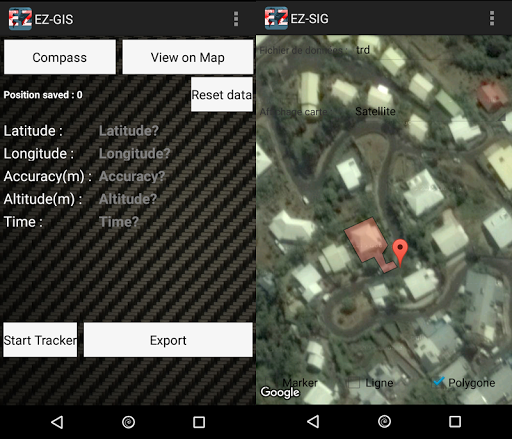
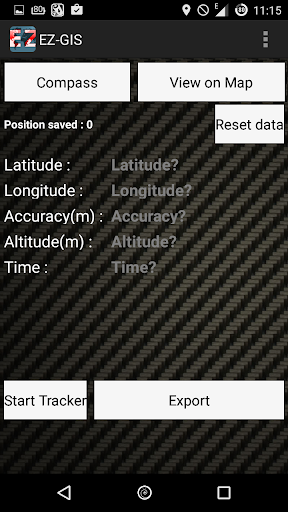
L'applicazione può registrare i posizioni in due modi diversi.
In primo luogo, lascia la mano ed è necessario recuperare manualmente i diversi punti geografici coordinati alla mia richiesta (ideale per fare riferimento a specifiche aree).
In secondo luogo, una modalità automatica o inseguitore che tiene traccia di movimento e di backup dei dati di registrazione ogni X secondi possono tracciare il movimento e visualizzarli su una mappa (ideale per riferimento i viaggi)
Questo software location-based permette di esportare i file in formato CSV leggibile in più mappatura o software GIS.
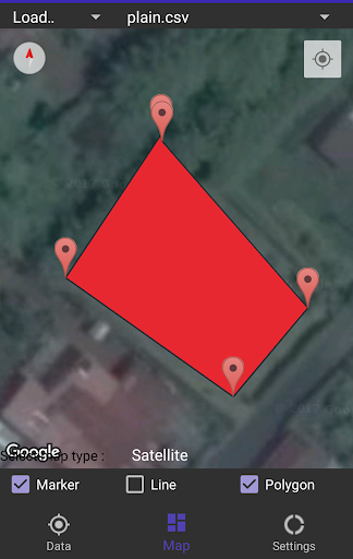
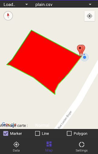
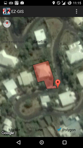
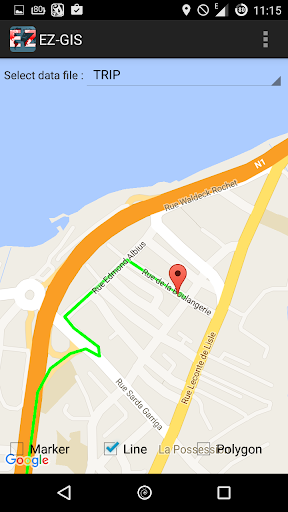
Inoltre EZ GIS offre la possibilità di visualizzare il percorso o esportare il vostro movimento registrato su una mappa Googlemaps.
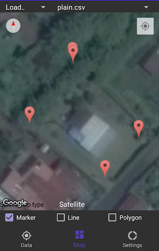
La scheda permette di visualizzare i dati in forma di poligono o linea o semplicemente come forme marcatori
Un ottimo strumento per sostituire costosi XY GPS
Lo strumento è stato sviluppato specificatamente per l'utilizzo con il software di mappe e GIS come QGIS, ArcGIS, GRASS GIS, gvSIG, GIS Collettore, ILWIS, JUMP GIS MapWindow GIS, SAGA GIS, uDig, Capaware, FalconView, Kalypso , TerraView, Whitebox GAT, MapGuide, Mapnik, MapServer, PostGIS, SpatialLite, TerraLib, cesio, GeoTools, GDAL, Orfeo Toolbox, GeoNetwork, pycsw, Camaleonte, MapPoint, GoogleEarth, Google Earth, Autodesk, ENVI, ERDAS IMAGINE, strumenti di Esri, GeoServer & Excel o Manifold GIS e altri strumenti per leggere i file CSV. Allora, qual è lo strumento essenziale per la mappatura vostre indagini archeologiche e le indagini geografiche.
Inoltre, per i nuovi utenti di QGIS, EZ GIS offre un tutorial passo passo per importare i dati in QGIS e facilitare l'utilizzo dei dati.
**
EZ GIS is the easiest tool to obtain, export, and use your geographic coordinates or locality , in various formats. (Latitude / Longitude, DMS Degrees Minutes Seconds, WSG83, UTM, OSGB36) with an accuracy of up to 1 meter. Ideal for mapping, surveying and prospect
This gis tool, carto tool is compatible with QGIS , ArcGIS , GRASS GIS ,
gvSIG , Manifold GIS , ILWIS , JUMP GIS , MapWindow GIS , SAGA GIS , uDig , Capaware , FalconView , Kalypso , TerraView , Whitebox GAT , MapGuide , Mapnik , MapServer , PostGIS , SpatialLite , TerraLib , Cesium , GeoTools , GDAL , Orfeo toolbox , GeoNetwork , pycsw , Chameleon , MapPoint , GoogleEarth, Google Earth, Autodesk , ENVI , ERDAS IMAGINE , Esri tools , GeoServer & Excel
Carto tool, Localization tool specifically developed for archaeological and geographical exploration. work on your carto will become easier! use your position and your coordinate points, lat lng and more!
This location the new research tool for cartography , map work , scaling & leveling
You can say goodbye to expensive XY GPS
Moreover EZ GIS offers you the ability to view your plot or export your recorded movement on a map googlemaps.
The map allows to display your data in the form of polygon or line or just under marker form
An excellent tool to replace expensive GPS XY
This application is going to be your best friend if you do archeological survey and/or geological survey or simply work on mapping


9Apps 4.9


