
Do you believe? 20,000+ users downloaded Maps Offline latest version on 9Apps for free every week! It is a wonderful app that amazes every player. This hot app was released on 2018-07-29. Read the following paragraph to see more information.
Remember you favourite mushroom places or find your way back to you hotel using this handy application. GPS Offline Utility offers an offline GPS interface which allows you to store locations offline, and then get pointed towards the location you want to revisit. For when you do have internet access, the app also provides a google maps environment where you can see, modify and add locations, which will then be available to you when you are offline and out in the 3G-free wilderness.
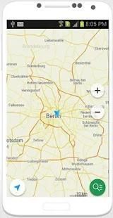
gps offline maps 2018 is an easy to use application. Show your current location on map. you can search any place nearby you or can search any address.
Fields Area Measurement is useful to calculate GPS area or GPS distance with great accuracy. There two way to measure any GPS area or distance
GPS Data - essential application for all GPS users.
Presentation of all GPS data from device
Position, satellites, gps signal strength
Gps diagnose and gps testing
Splendid user interface: 2 color themes
Features:
- Fast area/distance Mapping.
- Smart Marker Mode for super accurate pin placement.
- Measurement saving and editing
- Measurement Unit Changing Facility.
- Map, Satellite, Terrain and Hybrid modes
- Area Search Facility.
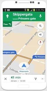
- Free offline GPS navigation
- Offline maps
- Lifetime free map updates
- Speed limit warnings
- 3D buildings
- Large POI database
- Pedestrian, car, or even bee-line navigation
- Night mode based on local sunset time
Extended features:
- Real-time traffic
- Multi-language voice navigation
- Speed camera warnings
- Lane guidance
- Land based surveys
- Farmers, for farm management
- Land record management
- Construction surveys
- Agronomists
- Town planners
- Construction surveyor
- Health, Education and facilities mapping
- Farm fencing
- Sports track measurement
- Construction sites and building sites area
- Asset mapping
- Landscape artists
- Landscape design
- Track recording
- Navigate to photo
- Travelbook
- Support
- A tool to find the directions when you fear to lost your directions via direction Google Map
- Support Zoom out by push on Marker or
- Show your position on Google Map background with latitude - longitude
- Shows degrees in “side window”
- Display latitude, longitude and altitude
- GPS Location update
- Select the best network connection automatically (Wifi, 3G, GPS)
- True north/Magnetic north
- 2 compass design/styles and 3 themes to select
- Quick Calibration
- Customizable coordinate format, sensor rate, text size, text color, unit
- Menu shortcut button on main screen
- Keep screen awake
- Rotating bezel
- Support Map Coordinates
- Find easiest and fastest route for your destination.
- Easily track all the locations you have visited.
- Find Address of any area in map by search option or touch on map.
- Easily delete your complete location history just by one click.
- Best GPS Route Finder app for android.
- GPS Route Finder is completely.
Displays all the GPS and sensor data you ever were curious about: position and signal strength of satellites, accuracy, speed, acceleration, altitude, bearing, pitch, roll and battery state.
Tools provided: compass with magnetic and true north, leveling tool, waypoints: mark or share your location and navigate back later using the Radar (especially useful for geocaching, or quickly marking your actual position).
9Apps 4.9