As we all know, 10,000+ users downloaded Bangkok Skytrain Subway MAP HD latest version on 9Apps for free every week! This makes the app feel more like a popular merchandise, which is very positive in my opinion. This hot app was released on 2013-07-09. More similar hot applications can be found here too.
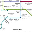
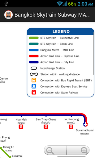
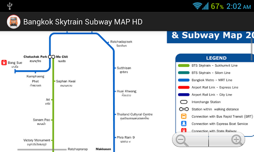
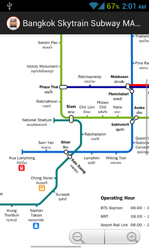
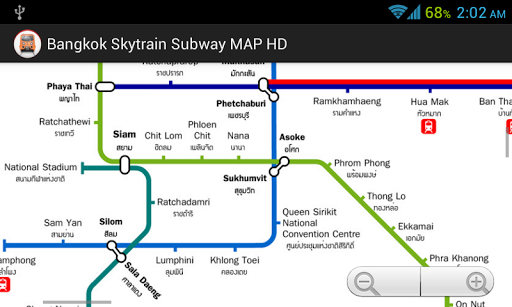
SystemThe present Bangkok mass transit system comprises two different types of metros: 1) the elevated BTS system, the so-called Skytrain - rot fai fah in thai and 2) the underground MRT subway. Although BTS and MRT use similar technology (trains, signalling & train control), there is no track connection between them. All MRT stations are equipped with platform-screen-doors, which does not apply to any BTS station.Besides the mass transit rail systems, water Buses provide a fast transport service on the Chao Phraya River; at present, transfer to the BTS system is only possible at Saphan Taksin station.Green Lines (BTS-Skytrain) This is a completely elevated system built by Siemens as a turnkey project, opened in 1999, initially 23 km long with 23 stations. The BTS system consists of two lines: the Sukhumvit Line (22 km) and the Silom Line (8.5 km).Track gauge is 1435 mm and power supply is via third rail at 750 V DC. 3-car trains are 65 m long (a fourth car being added to all trains between 2012 and 2013), air-conditioned and run at an average speed of 35 kph. Saphan Taksin station on the Silom Line was only planned as a temporary station, but as it offers an excellent connection to the Water Buses on Chao Phraya River, it remains open after the extension to Wongwian Yai, although the single-track section at Saphan Taksin station limits the capacity on the Silom Line. The elevated Green Line depot is connected to Mo Chit station.05 Dec 1999: basic BTS network - Sukhumvit Line Mo Chit - On Nut- Silom Line national Stadium - Saphan Taksin15 May 2009: Silom Line Saphan Taksin - Wong Wian Yai12 Aug 2011: Sukhumvit Line On Nut - Bearing (5.25 km)12 Jan 2013: Silom Line Wong Wian Yai - Pho Nimit 14 Feb 2013: Silom Line Pho Nimit - Talat PhluBlue Line (MRTA)In August 1997 construction work began on this 21 km underground full metro with 18 stations; it finally opened for trial service in April 2004. In December 2001, Siemens was awarded the contract to build 19 three-car trains for this line and to provide the necessary operating equipment.A 1-station extension from Bang Sue to Tao Pun is planned to create an interchange with the future Purple Line; the Blue Line would be on surface at Tao Pun station.The standard Blue Line station has an island platform on level -3. Sam Yan, Silom and Lumphini stations have side platforms on different levels, each with trains to Bang Sue on level -2, and trains to Hua Lamphong on level -4, whereas Bang Sue and Khlong Toei stations have two side platforms on the same level. Thailand Cultural Centre is much bigger than other comparable stations: the Blue Line stops on level -3, while level -2 is prepared to accommodate the Orange Line in the future. The surface Blue Line depot is connected directly to both Thailand Cultural Centre and Phra Ram 9 stations. A track connection between Blue and Orange Lines will be made via this depot.City Line & Airport Rail Link28 km elevated line with 8 stations, standard gauge, from Phrayat Thai via Makkasan/City-Terminal to Suvarnabhumi Airport), every 15 minutes, shared with special non-stop airport express which departs from Makkasan/City-Terminal, opened for commercial operation on 23 August 2010.23 Aug 2010 - City Line & Airport Rail Link


9Apps 4.9


